
HuiYanEarth-SAR Fools Expert Analysts 35% of the Time With Fake Radar Imagery
A new diffusion model generates realistic SAR satellite imagery anywhere on Earth from just latitude and longitude, using AlphaEarth embeddings as a geographic prior.
 Pro
Takeaways
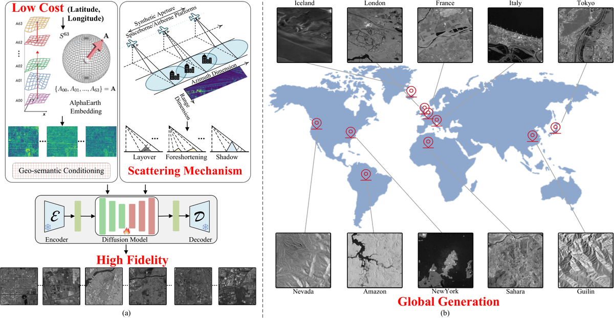
- HuiYanEarth-SAR generates high-fidelity SAR imagery worldwide from geographic coordinates alone via a new diffusion foundation model.
- Uses AlphaEarth 64-D embeddings as ControlNet conditioning plus LoRA fine-tuning on Stable Diffusion.
- Offset noise and Min-SNR loss weighting implicitly encode SAR scattering physics without explicit physics modules.
- Expert SAR interpreters misclassified generated images as real 35 percent of the time, matching real SAR imagery.
- Augmenting training data 5x lifted ResNet34 scene classification accuracy from 92.55 to 96.79 percent.
- Code released on GitHub; trained on 8 NVIDIA 4090D GPUs using Sentinel-1 and Sentinel-2 aligned patches.
Synthetic Aperture Radar imagery is one of remote sensing's most useful yet stubbornly scarce data types. It works day or night and sees through clouds, but acquisition is expensive, and labeled datasets are tiny compared to what modern deep learning wants. A team from the National University of Defense Technology has released HuiYanEarth-SAR, a diffusion-based foundation model that generates realistic SAR images for any location on the planet using only geographic coordinates as input.
The approach piggybacks on Google DeepMind's AlphaEarth Foundations model, which acts as a kind of virtual satellite. AlphaEarth assimilates observations across diverse sources of geospatial information, including optical and thermal imagery from Sentinel-2 and Landsat, radar data that can see through clouds, 3D measurements of surface properties, global elevation models, climate information, gravity fields, and descriptive text. It produces a global dataset of precomputed, analysis-ready embeddings at 10-meter resolution for each year back to 2017. HuiYanEarth-SAR turns those 64-dimensional embeddings into a conditioning signal that tells a diffusion model what the ground actually looks like at any coordinate.
Why SAR generation is hard
Optical satellite image synthesis has advanced fast, with models like MetaEarth already generating coordinate-conditioned optical imagery worldwide. SAR has lagged because its imaging physics work differently. Signal intensity and phase are coupled with sensor parameters, terrain geometry, and surface dielectric properties, and every image carries multiplicative speckle noise. Existing SAR generators mostly focus on specific targets like ships or vehicles under narrow viewing angles, so they cannot scale to arbitrary natural or urban scenes.
The authors frame this as a mismatch between two levels of fidelity: macroscopic geospatial semantics (is that a harbor, a forest, or the Amazon?) and microscopic scattering behavior (do mountain slopes facing the radar light up while slopes facing away go black?). Previous methods tend to handle one and fail at the other.