HKU's D-BDM Cuts Robot 3D Mapping Memory by 89% at High Resolution
A new occupancy grid framework skips 98% of voxel traversals during LiDAR mapping updates and cuts memory use versus prior boundary methods.
 PRO
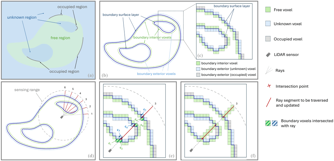
- D-BDM extends boundary-based occupancy mapping with truncated ray casting that only updates voxels outside the boundary surface.
- Traversed voxel count drops to about 2% of classical ray casting after the first scan.
- At 0.1 m resolution, update time is 2.8x faster than D-Map and 18.2x faster than OctoMap on Town_03.
- Direct boundary update eliminates the auxiliary local 3D grid, cutting memory 38.6% versus BoundaryMap on the college sequence.
- Validated on HeLiPR, KITTI, Newer College datasets and a Livox MID-360 drone flying in a multi-floor building.
- Uses discrete free/occupied/unknown labels but still supports dynamic environments, unlike D-Map.
Real-time 3D mapping is one of those problems that sounds solved until you try to run it on a drone. Store every voxel in a big grid and memory explodes. Use an octree and every query pays a logarithmic tax. Ray-cast from every LiDAR point and the update loop chokes on high-resolution sensors. A team from HKU's MaRS Lab and KTH has proposed D-BDM, a mapping framework that rethinks what you actually need to touch when a new scan arrives.
The core idea builds on their earlier BoundaryMap work, which observed that you don't need to store every free voxel in the world. The boundary between free space and the unknown-or-occupied region is a 2D surface, and once you have that surface you can answer any occupancy query. D-BDM keeps that low-dimensional representation and adds two update-side tricks that make it faster and lighter.
Where full ray casting burns cycles
In traditional occupancy grid mapping and in BoundaryMap alike, each point in a sensor scan updates the corresponding voxel toward occupied, and a ray is cast from that point back to the sensor origin, updating every voxel along the way toward free. That work is expensive: a vast number of voxels get traversed and updated, especially with high-density, long-range sensors like LiDARs, which prevents real-time performance.
This story is for Pro members
You've reached the end of the free preview. Upgrade to AlphaSignal Pro to read the full article - and everything else behind the paywall.
Comments