Google's Planetary Prediction Engine Turns Weeks of Geospatial Work Into Minutes
Google Research unveils an autonomous AI system that turns natural-language questions about food security, disease, and climate risk into trained geospatial models in minutes.
- Google Research introduced the Planetary Prediction Engine, an autonomous system for geospatial modeling from natural-language queries.
- PPE runs three LLM-orchestrated stages: data selection, multimodal curation with anti-leakage checks, and automated model training.
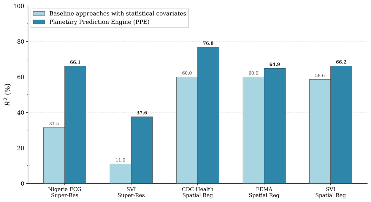
- Beat expert baselines on 21 CDC health indicators (76.8% vs 60.0% R²) and FEMA/SVI spatial regression tasks.
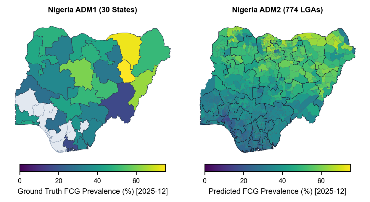
- Doubled accuracy on Nigeria food security downscaling from state to local government area (66.1% vs 31.5% R²).
- Achieved 83.3% Recall@10 nowcasting the 2026 DRC Ebola outbreak, +10.3 points over Bayesian state of the art.
- Fuses structured covariates with AlphaEarth and PDFM embeddings; currently an experimental research capability with no public API.
Building a planetary-scale prediction model has historically been a multi-week ordeal. Specialists hunt down satellite data, health surveys, weather records, and demographic layers, then stitch them into a training set before any modeling begins. Google Research just introduced the Planetary Prediction Engine (PPE), an experimental capability inside its Earth AI stack that automates the entire loop, from data discovery to trained model, directly from a natural-language query.
PPE targets a specific pain point that generic AutoML never solved: geospatial workflows depend on fragmented, oddly-shaped data with strict spatial and temporal join rules. The system collapses weeks of manual data engineering into minutes of autonomous execution, and beats expert baselines across public health, food security, and disaster risk benchmarks.
From a question to a trained model in three stages
PPE decomposes the workflow into three LLM-orchestrated stages that pass data through opaque handles rather than serializing everything into prompt context, which sidesteps context window limits.
- Intelligent geospatial data selection. The system parses a query into strict geographic constraints (granularity, join keys, temporal window), forms hypotheses about which signals matter, and validates them against published literature. It then pulls covariates from repositories like Data Commons and Google Earth Engine, falling back to live open-web search across government portals and academic sources when a signal is missing.
- Multimodal dataset curation. Structured covariates get fused with two pre-trained embedding families: Population Dynamics Foundation Models (PDFM) for socio-demographic latent state, and AlphaEarth for satellite imagery semantics. A Feature Gate then runs every candidate covariate against four anti-leakage checks, filtering out mathematical sub-components of the target, shared survey artifacts, downstream causal effects, and future temporal data.
- Automated model building. PPE searches across regularized linear models, gradient-boosted decision trees, and MLPs. An Overfitting Guard Protocol pre-scores dataset risk and runs a self-correction loop when generalization fails.
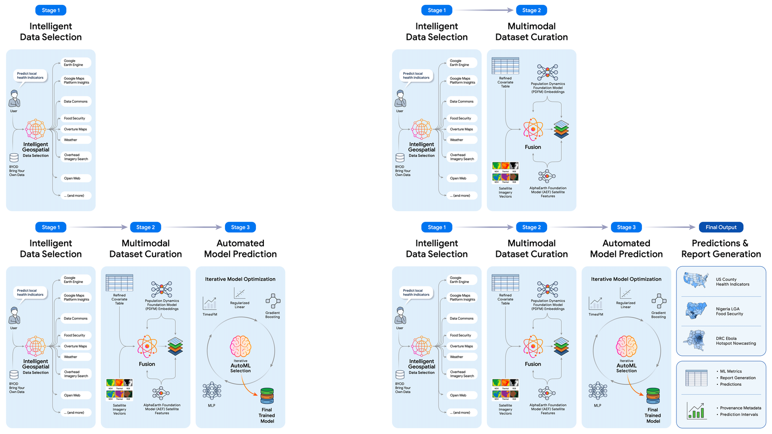
The system is described in an accompanying paper, Planetary Prediction Engine: Autonomous Geospatial Prediction via Intelligent Data Selection and Foundation Model Embeddings, with contributors spanning Google Research, WFP, and INRB.
Benchmarks that punch above manual pipelines
Google evaluated PPE across a matrix of ML paradigms, geographies, and domains. The pattern is consistent: intelligent data selection plus multimodal fusion beats manually engineered baselines by wide margins.
| Task | Baseline | PPE |
|---|---|---|
| CDC health indicators (21 metrics, spatial regression) | 60.0% mean R² | 76.8% mean R² |
| FEMA National Risk Index | 60.0% mean R² | 64.9% mean R² |
| Social Vulnerability Index | 58.6% mean R² | 66.2% mean R² |
| Nigeria food security downscaling (ADM1 to ADM2) | 31.5% R² | 66.1% R² |
| DRC Ebola nowcasting (Recall@10) | ~73% | 83.3% |
The Nigeria case is the most striking result. Reporting on food consumption in data-scarce regions typically stops at the state level, obscuring where local vulnerability actually concentrates. PPE more than doubled downscaling accuracy by pulling in localized market shocks, food price anomalies, and microclimate indicators, producing high-fidelity vulnerability maps at the local government area level.
The Ebola experiment is the closest thing to a live stress test. During the 2026 Bundibugyo ebolavirus outbreak in the DRC, PPE correctly identified 15 of 18 newly invaded health zones across five sequential weekly forecasts, a 10.3 percentage point absolute lift over the published Bayesian modeling state of the art. The gain came from fusing epidemiological signals with PDFM embeddings and PPE-selected covariates.
Why the fusion matters
The ablation story is worth pausing on. Structured covariates give you explicit, interpretable signals: median income, temperature anomalies, road density. Foundation model embeddings like AlphaEarth Foundations and Population Dynamics Embeddings encode nonlinear patterns learned from massive pre-training corpora, patterns no analyst would surface by hand. Neither modality captures the full picture alone, and Google's ablations consistently show they are complementary rather than redundant.
This continues a thread Earth AI has been developing, where fusing socio-economic embeddings from Population Dynamics Foundations with landscape embeddings from AlphaEarth Foundations improved prediction of FEMA's National Risk Index by an average of 11% in R² across 20 hazards, compared to using either source alone.
Where PPE sits in the Earth AI stack
Google has been assembling geospatial primitives for a while. Earth AI unites Google's decades of geospatial models with reasoning powered by Gemini, and the platform already ships things like Flood Hub, covering river basins in over 100 countries and providing flood forecasting to a population of 700M people. PPE closes the loop between those primitives and end-to-end predictive modeling.
The broader agent framing matters here. Earlier Earth AI work described a natural language, map-based interface where an agent interprets a user's query, breaks it into sub-tasks, delegates each to the appropriate expert tool, and synthesizes the final response. PPE extends that pattern from question answering to full model training and evaluation.
Who this actually helps
PPE is positioned as an experimental research capability, not a product with a pricing page or a public API. There is no self-serve access announced. The target users are clear from the case studies:
- Humanitarian organizations that need vulnerability maps at higher spatial resolution than official reporting provides
- Public health agencies running spatial regressions across dozens of health indicators without a dedicated geospatial engineering team
- Disaster risk analysts predicting hazards like flooding or wildfire risk at fine geographic granularity
- Epidemiologists nowcasting outbreak spread when timely response matters more than a perfectly tuned custom model
The honest limitations
Two caveats deserve attention. PPE inherits whatever biases live in its data sources, and its Feature Gate mitigates target leakage but does not fix underlying survey coverage gaps or reporting delays. The paper's baselines are also strong but domain-specific; a Bayesian model tuned by an epidemiologist for months may still beat PPE on the exact task it was designed for, even if PPE gets 80% of the way in minutes. The value proposition is speed and breadth over beating every specialist on their home turf.
What actually shifts
Geospatial modeling has long been gated by tacit knowledge: which data source to trust, how to align a health survey with a satellite embedding, which covariates leak. PPE encodes that tacit knowledge into an autonomous loop, which pushes analysts up the stack toward hypothesis framing and interpretation. If the results generalize beyond the reported benchmarks, the definition of who can run a planetary-scale study will widen considerably.
Comments