Google Research's ME-POIs Beats Gemini Embeddings at Reading Real Places
Google Research unveils ME-POIs, a framework that fuses anonymized foot-traffic patterns with text embeddings to improve place understanding by up to 81.9%.
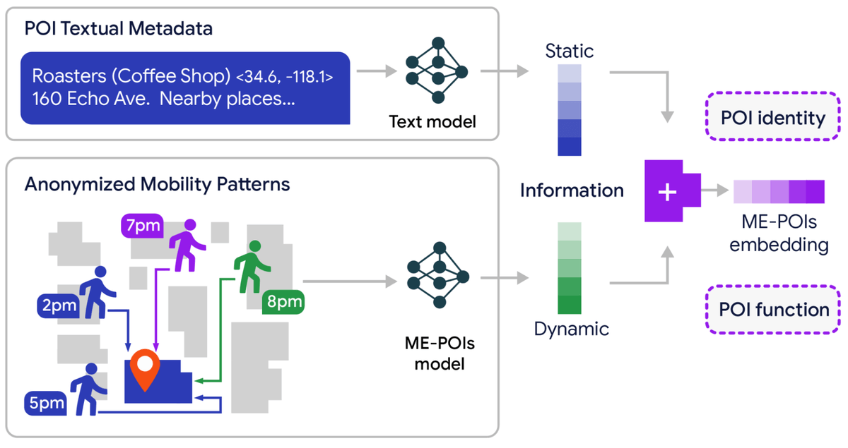
- Google Research introduces ME-POIs, fusing text embeddings with anonymized mobility patterns for place understanding.
- Up to 81.9% relative gain in visit intent prediction and 75.1% in price classification versus baselines.
- Three-step pipeline: visit alignment, spatial multiscale propagation, and text-mobility synergy via cosine similarity.
- Spatial propagation solves data sparsity by borrowing visit patterns from data-rich neighboring places.
- Tested on LA and Houston across five tasks including hours, closure detection, and busyness forecasting.
- Full details in the arXiv paper; aggregate-only, no individual personalization.
Language models are surprisingly good at describing a coffee shop but surprisingly bad at knowing when it's actually open, whether it draws a brunch crowd or a late-night one, or if it quietly went out of business six months ago. Google Research wants to close that gap between a place's paper identity and its lived reality with a new framework called Mobility-Embedded POIs, or ME-POIs.
Laid out in a blog post and accompanying paper, the approach enriches standard text-based place embeddings with anonymized, aggregated visit patterns so models can reason about the temporal rhythm of a location rather than just its metadata. Combining ME-POIs with advanced text models delivered up to an 81.9% relative gain in predicting visit intent, a 75.1% improvement in price-level classification, and a 24.7% increase in busyness estimation accuracy across unseen places.
Where static text embeddings run out of road
Traditional language models build representations of points of interest, whether a business, a park, or a landmark, by leaning heavily on static metadata. They parse addresses, business categories, and text descriptions well, but they miss the operational context that makes a place actually useful. A model looking at "Joe's Diner, American food" has no idea whether the counter fills up at 7am or the rush hits at midnight.
Prior geospatial AI research applied mobility patterns almost exclusively to predicting the next POI a user will visit. ME-POIs flips that setup, treating mobility as a feature that defines the place itself.
Inside the three-step pipeline
The framework transforms raw location data into a dense embedding through three stages, each targeting a specific weakness of text-only representations.
- Visit alignment. The model treats aggregate visits to a specific POI as fundamental data points, analyzing temporal arrival windows, departure trends, and typical stay durations. A temporal encoder maps these sequences into a dense vector space, establishing a functional centroid: a unique multidimensional signature covering aggregate anonymized mobility patterns over a one-year cycle and across days of the week.
- Spatial multiscale visit propagation. This is the clever bit that solves the long-tail problem. The architecture recognizes that visits are usually regionally constrained, so a small boutique on a high-end shopping street shares systemic behavioral traits with its neighbors. The framework looks at adjacent places across multiple spatial scales: the immediate street, the block, and the wider neighborhood. It then statistically transfers the aggregated visit patterns of busy, data-rich neighbors to nearby sparse places.
- Text-mobility synergy. The framework aligns high-level language embeddings (the standard vector representations extracted from advanced models like Gemini) with the newly generated mobility vectors by maximizing their cosine similarity. The result is a hybrid signature that preserves what a place says it is while absorbing what it actually does.
The long-tail win
Data sparsity is the quiet killer of geospatial models. Famous landmarks, massive malls, and popular downtown chains generate abundant visit data, while the vast majority of local businesses suffer from severe sparsity. Previously, when a model encountered a place with few or no recorded visits, it would incorrectly assume the place had zero activity, leading to broken predictions. By borrowing rhythm from the neighborhood, ME-POIs can produce useful embeddings for a new cafe that has almost no visit history of its own.
What the benchmarks show
The team evaluated the framework across two culturally distinct metropolitan areas, Los Angeles and Houston, then tested on unseen places to check for generalization rather than memorization. The five downstream tasks cover the practical questions any mapping product cares about:
- Opening and closing hours prediction
- Price-level classification (thrift shop vs. luxury boutique)
- Permanent closure detection, catching businesses that have gone dark before anyone updates their profile
- Visit intent classification as a proxy for popularity
- Busyness forecasting for peak-hour dynamics
Baselines included standard text-only embedding models like Gemini embeddings, existing trajectory-based geospatial models like TrajGPT, and hybrid variations to isolate exactly how much value the mobility patterns added.
The most interesting finding is buried in the ablations. When comparing a model trained exclusively on mobility data against those with access only to text metadata, the mobility-only model surpassed the text-only language models in several cases, including price-level classification. Watching who shows up and when apparently tells you more about a business than reading its own description does.
Where ME-POIs fits, and where it doesn't
The framework targets aggregate place understanding, powering features like better hours estimation, price hints, closure detection, and busyness forecasts in mapping and search products. Google emphasizes that ME-POIs focuses on understanding the world in aggregate and cannot draw conclusions about individual users or anything personalized. It provides a holistic representation of how a place is visited across broad populations and time frames, and cannot be used for individual personalization.
For anyone building geospatial features on top of an LLM, the practical takeaway is that a Gemini embedding for a location is leaving signal on the table. Fusing it with aggregated mobility, even through a relatively simple cosine-alignment objective, materially changes what the model can infer, and it does so without forcing the downstream classifier to recompute those attributes from scratch each time.
Comments