Google DeepMind's WeatherNext 3 Ditches Physics Simulations for 60% Sharper Forecasts
Google DeepMind's new weather AI trains on raw satellite feeds and station data, delivering hourly 5km forecasts with up to 50% better rain accuracy.
- Google DeepMind released WeatherNext 3, an AI weather model trained on live satellite and station data.
- Hourly forecasts at 5km resolution, roughly 5x sharper than WeatherNext 2's 25km/6-hour grid.
- Up to 50% more accurate precipitation forecasts, with 60% CRPS improvement against IMERG benchmarks.
- Includes turbine-height wind and solar radiation outputs aimed at renewable energy grid operators.
- Powers weather in Search, Gemini, Maps, and Maps Platform Weather API starting today.
- Developers can access data via BigQuery, Earth Engine, and Cloud Storage.
Weather forecasting has quietly become one of deep learning's most successful applications, but the field has carried a stubborn limitation: most AI weather models still learn from physics-based simulations, not the atmosphere itself. Google DeepMind's WeatherNext 3 breaks that dependency by training directly on live satellite feeds and raw weather station observations, producing hourly global forecasts at up to 5-kilometer resolution.
Independent live evaluations by Brightband now rank it as the most accurate global weather model available. Google is already rolling it into Search, the Gemini app, Google Maps, and the Maps Platform Weather API, with the underlying data exposed to developers through BigQuery, Earth Engine, and Cloud Storage.
Dropping the six-hour lag
Previous AI weather systems consumed numerical weather prediction (NWP) reanalysis: the output of massive physics simulations run on supercomputers. Models like GraphCast and WeatherNext 2 depended on this pipeline, which carries a six-hour data lag and can introduce biases for fast-changing variables like precipitation or surface temperature.
WeatherNext 3 skips that intermediate step entirely. By ingesting a mosaic of live geostationary satellite data, it gets a continuously updating view of the atmosphere and generates a new forecast every hour, grounded in the most recent observations available. That represents a jump from WeatherNext 2's 25-kilometer grid running in 6-hour increments to hourly updates at up to 5-kilometer resolution.
How the architecture fits together
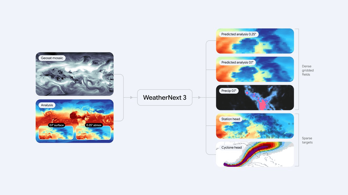
The system is built around what the team calls a Functional Generative Network (FGN) mesh transformer: a single flexible backbone that handles multiple output types simultaneously, which is unusual for a weather model. It produces:
- Dense gridded fields for standard variables like temperature, humidity, and wind
- Discrete cyclone tracks as structured predictions
- Station-level sparse coordinate predictions trained directly against ground observations
Different variables live at different resolutions inside a physically consistent output: surface variables like temperature and moisture at 5 km, other surface variables at 10 km, and atmospheric variables like wind speed at 25 km. The model ingests live 1-hour geostationary satellite mosaics alongside traditional historical analysis to feed that transformer backbone.
Training on sparse station data is one of the more consequential design choices here. NWP-trained models effectively learn a smoothed atmosphere, so coastlines, valleys, and mountain slopes get washed out. Training directly on sparse weather station observations lets WeatherNext 3 make global forecasts on a 5-kilometer grid that account for regional details like topography.
Sharper precipitation forecasts
Rain has historically been the hardest variable in global forecasting. Precipitation systems are driven by fast-moving cloud processes at tiny scales that are hard to capture with physics-based simulations, so AI forecasts often produce blurry estimates or miss the boundaries of severe storms entirely.
The team trains on two high-quality precipitation sources: NASA's satellite-based Integrated Multi-satellite Retrievals for GPM (IMERG) and their own global precipitation reanalysis based on satellite radar. In medium-range global forecasts, the model shows a Continuous Ranked Probability Score (CRPS) improvement of up to 60% against IMERG, 30% for MRMS, and 10% against rain gauge measurements for early lead times. CRPS is a standard metric for probabilistic forecasts that penalizes both wrong predictions and overconfident ones.
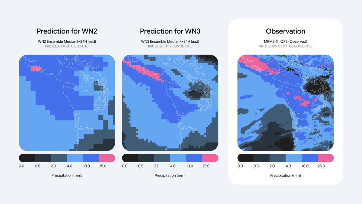
The qualitative difference is visible in the comparison above. WeatherNext 2's 25-kilometer precipitation footprint is diffused and pixelated, while WeatherNext 3 at 11-kilometer resolution mirrors the satellite ground truth, capturing the sharp convective bands of the weather systems.
New outputs worth knowing about
Beyond raw accuracy, the model adds several outputs absent from earlier releases. It forecasts 100-meter wind speeds at roughly turbine height for precise wind-energy output, alongside high-resolution cloud cover and solar radiation levels to help solar farms estimate incoming light. Grid operators trying to match renewable supply to demand have a direct use case here.
Coverage is another meaningful gain. Latin America, Africa, and Asia-Pacific have historically been underserved by high-resolution forecasting because of the supercomputing costs of regional NWP models. A single global AI model running at 5 km changes that economics entirely.
How to use it
For end users, the improvements surface invisibly through weather cards in Search, Maps, and Gemini, with up to 50% more accurate precipitation forecasts for planning a day or more ahead, with the largest gains in historically less reliable regions.
For developers building on top of it, the access paths are:
- WeatherNext on Google Cloud for hourly-updated global predictions with no model setup
- Query the data in BigQuery or Earth Engine, or bulk-download from Google Cloud Storage
- The technical paper for FGN architecture details and full evaluation results
- Google Maps Platform Weather API for consumer-facing integrations
Two assumptions worth revising
The idea that NWP simulations must sit upstream of any AI weather model is now demonstrably wrong. Training directly on raw observations produces better forecasts once you have the scale of satellite and station data Google can assemble. The split between global coarse models and expensive regional high-resolution models is also closing: a single global model at 5 km, refreshed hourly, does the job that used to require a stack of regional systems.
Google notes the obvious caveat that WeatherNext 3 is not a replacement for official warnings, and genuine atmospheric unpredictability remains. Weather forecasting is nonetheless shifting from physics-first with ML assistance to ML-first grounded in raw sensor data, and WeatherNext 3 is currently the clearest example of how far that shift has gone.
Comments