CDIKTNet Localizes Drones From Satellite Imagery With Just 2% Labeled Data
A new drone-view geo-localization network learns from as little as 2% paired data and transfers to new environments without any pairing labels.
 PRO
- CDIKTNet does drone-to-satellite geo-localization with as little as 2% paired training data.
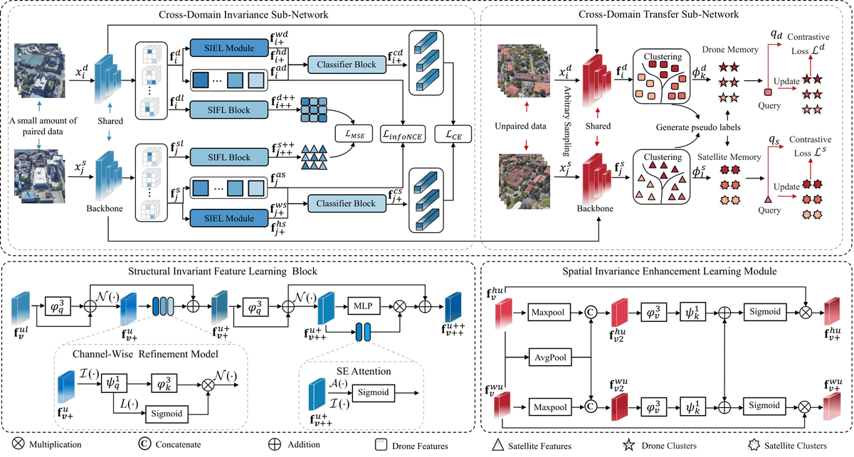
- Two sub-networks: CDIS learns cross-view invariance, CDTS runs contrastive learning on unpaired data.
- Hits 95.02% R@1 fully supervised on University-1652, matching state-of-the-art.
- At 2% labels: 85.63% R@1, roughly 20 points above supervised baselines like Sample4Geo.
- New cross-domain setting: train on one dataset with 2% pairs, transfer to another with zero pairs.
- Weakness: struggles on noisy low-altitude DenseUAV data under limited supervision.
Matching a drone's downward-facing camera to satellite imagery to figure out where it is sounds easy until you try it. Rooftops warp with viewpoint, scale shifts with altitude, and two intersections in the same city can look nearly identical from above. A new paper introduces CDIKTNet (Cross-Domain Invariant Knowledge Transfer Network), which tackles drone-view geo-localization (DVGL) with a fraction of the labeled pairs current methods demand, and can be dropped into a new environment with zero pairing information.
The paired-data trap
DVGL is usually framed as image retrieval across viewpoints: given a drone image, find the matching satellite tile. The authors point out that existing supervised methods strictly rely on large volumes of paired data to learn cross-view correlations, and when the supervised ratio drops to zero they become ineffective. Deploying to a new city typically means collecting fresh paired data and retraining from scratch.
Unsupervised approaches try to sidestep this by generating pseudo-labels from cross-view feature similarity, but cities are visually repetitive. When similar patterns appear at different geographical locations, the resulting feature confusion in the shared space produces incorrect pseudo-labels, which drives the model toward negative optimization. Bad labels beget worse features.
This story is for Pro members
You've reached the end of the free preview. Upgrade to AlphaSignal Pro to read the full article - and everything else behind the paywall.
Comments